Tuesday, November 30, 2021

Historic Jamestowne

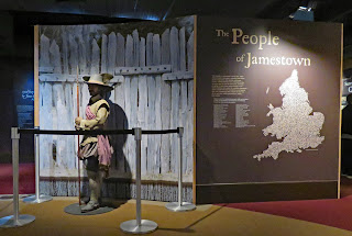
  Jamestown, established in 1907, is considered the first permanent English settlement in North America even though it lasted for less than 100 years. The settlement was sponsored by the Virginia Company of London as a money making venture in the belief that North America would as rich in gold as South America. The first settlers were gentlemen soldiers and their manservants. They spent valuable time searching for gold rather than digging wells, constructing shelters, and storing up food supplies. All of that combined with hostile Native Americans, a continuing drought, disease-bearing mosquitoes, and the late arrival of supply ships resulted in illness and starvation. The winter of 1609–10 brought death to over 400 settlers.
   Even with all of the problems the excellent deep-water port at Jamestown which allowed ships to sail close to the river banks for loading and unloading cargo meant that the location would not be easily abandoned. As more settlers and supplies arrived it became a thriving town of several thousand people and the location of the capital of the Virginia Colony. In 1699 the capital was moved to the more suitable location of Williamsburg, Virginia and by the 1750s the Jamestown peninsula was farmland owned primarily by the Travis and Ambler families.
  The town site  was largely forgotten and had reverted back to forest in 1893 when 22 1/2 acres were donated to the Association for the Preservation of Virginia Antiquities. Archaeological investigations turned up foundations of the first churches. A memorial church was built on top of the foundations in 1907. In 1934 the National Park Service purchased the remaining 1500 acres. Since the island is owned by both organizations the fee schedule  is confusing. It’s not free with a National Park pass but it is discounted. It is free with an Access Pass for both the pass holder and an assistant.
  The visitor center is accessible. The museum and theater were closed due to coronavirus. We joined a walking tour of the fort area which was very informative. We also rolled/walked on all of the trails in both the Jamestown Fort and New Towne sections of the island. The trails are surfaced with gravel and wheelchair users may need assistance. The Archaearium Archaeology Museum is accessible. The reconstructed 1608 Glasshouse is located off site and has an accessible trail from the parking lot.

   
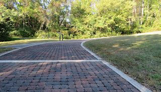
  The parking lot for Historic Jamestown has RV/bus sites. It’s a bit of a trek to visitor center so visitors with small RVs may be able to park in the car lot. The Glasshouse lot is large enough for RVs. RVs are not permitted on the Island Drive loop road. They’re paved and open to cars, bikes, and pedestrians. Jamestowne  37.21042, -76.77529

Sunday, November 28, 2021

Thomas Stone National Historic Site

  At 33 years of age, Thomas Stone was the youngest  signer of the Declaration of Independent. He came from a wealthy family and was a lawyer when he bought the property now owned by the national park. Formerly a tobacco plantation, the land had been worked out but was still suitable for raising livestock, grain, fruits, and vegetables which were tended by 25- 35 slaves. The house that Stone had built in 1771 was in the family until 1936.

  The house is open for tours but during our visit it was closed due to coronavirus. The visitor center has a few exhibits. A couple of trails loop through the property and provide access to the outbuildings and tenant house.

  The visitor center is accessible. The trail to the house starts as a boardwalk but the majority of it is over lumpy, grassy ground which is tough to push through. The loop trails are also grassy and a hill south of the tenant house is extremely steep. I do not recommend trying the loop trails. There’s an accessible parking space at the house so driving to it may be an option. There’s ramp to one section of the house
      

The parking lot is large enough for any RV. Park  38.53027, -77.03588

Friday, November 26, 2021

Smallwood State Park

  The 984 acres of this park was once part of General William Smallwood’s tobacco plantation. Smallwood served in the Continental Army during the Revolutionary War and also as the 4th governor of Maryland.

  The park is located on the Mattawoman Creek where it flows into the Potomac River. None of the sites border the creek but there is a marina and boat ramp. Smallwood’s house has been renovated and is open to tour on very limited dates. A couple of trails meander through the property.

   I don’t like to make reservations because it’s hard to tell the condition of the sites and plus there’s often a reservation fee which makes the campsite expensive for a one night stay. Occasionally  that backfires. Due to coronavirus all sites at Smallwood must be reserved. Our internet was slow to bring up the park site and we had to call the Maryland park office with only minutes to spare before it closed. Luckily we ended up with a very nice site.

The park has 15 sites. None are designated as accessible but many can be used. We did not walk the trails because of the  cold weather and recent rains. The house wasn’t open. Park  38.55304, -77.1872

Thursday, November 25, 2021

Theodore Roosevelt Island

 
   Throughout the years, this little island in the middle of the Potomac River, has sheltered a Native American village, a colonial plantation, and the training grounds for Black Union soldiers. In 1931 the Theodore Roosevelt Memorial Association bought the island. The Civilian Conservation Corps cleared brush and planted trees to make a fitting memorial for Roosevelt, an avid outdoors man, who, as president created, five National Parks, 18 U.S. National Monuments, 51 bird reserves, four game preserves, and 150 National Forests.

The island features a large statue of Roosevelt and several miles of trail.

  Some of the trails are surfaced with gravel; others are boardwalk. Most wheelchair users will need assistance due to many obstacles – large stones, damaged boardwalk, uneven surfaces, and hilly terrain. It’s not possible to navigate a wheelchair along the entire Swamp Trail, which circles the outer edge of the island, due to steep, washed out sections.
  RVs can be parked lengthwise across the parking lot spaces. Check the height restrictions on the George Washington Memorial Parkway before driving on the parkway.  Island  38.89642, -77.06492


Tuesday, November 23, 2021

Slave Quarters at Arlington House

  We visited Arlington Cemetery and Arlington House in 2015. Since then the Slave Quarters museum was updated and focuses on the families that lived in the two quarter buildings. Each building is divided into three units. The units are small but much nicer than average slave quarters because of their close proximity to the house. The slaves that lived in them were maids, cooks, carriage drivers, and other household workers.
The exhibits also tell the stories of the descendants of Martha Washington’s grandson, George Washington Parke Custis, who fathered a daughter with Arianna, one of his slaves. Several hundred people are descendants of their daughter, Maria.
  The paths around the house and the quarters have been paved, an upgrade from our previous visit, so it’s much more accessible. The property slopes up from the Potomac River. Be prepared for hilly terrain. Wheelchair users will need help from an energetic pusher. An easier option is to take the shuttle bus tour which is accessible and free to visitors with a handicap placard and also free for one companion. The shuttle stops at most of the major sites.

  Follow the signs for RV parking. We did not have to pay a parking fee this time which may have to do with coronavirus. Quarters  38.88127, -77.07288

Sunday, November 21, 2021

C&O Canal Towpath–Great Falls

   Construction on the C&O Canal began in 1828 and ended in 1850. When completed it connected the tidewater of Washington, D.C. to Cumberland, Maryland, a distance of 184.5-mile. Fish, salt, bricks, and potatoes went upstream; pork, lumber, grain, coal, and stone headed downstream on the return trip.
   By the 1920s the railroads became the major cargo carriers and the canal fell into disrepair. In 1938 the US government became the  owner of the canal and young men of the CCC were put to work repairing the canal and locks. Additional repairs have been sporadic over the years, slowed by flooding and changes in political parties but by 1960 the entire 184.5 miles could be hiked and biked. The canal became a National Historic Park in 1971.
   We took a walk along the towpath from the Great Falls Tavern Visitor Center south for about 1 1/2 miles to where the canal widens at Turtle Rock. We also detoured to the Great Falls Overlook Trail which has great views of the rocky Potomac River. There’s no way that a boat full of cargo could navigate those waters!
  The canal path is surfaced with finely crushed rock and is accessible. The Great Falls Trail is a combination of sandy soil and boardwalk. Wheelchair users may need assistance on a steeply arched bridge. The view at the end of the trail is blocked by the top of the railing. The visitor center was closed but it is accessible.
 
 
  The parking lot is very large. RVs can be parked lengthwise across the spaces. Towpath  39.00483, -77.24554


Saturday, November 20, 2021

Huntley Meadows Park

 In the antebellum era Huntley Meadows was part of a large plantation owned by the Mason family. Thomas Francis Mason built a house on a hill in 1825 where he could sit on the front porch and overlook his holdings. The house has been restored and is open for tours at 10:30, spring through fall. Interpretive signs explain the history and uses of the three buildings on the property.
 The meadows have reverted to a forest and wetlands environment with a 1.7 mile trail of boardwalk and hard packed dirt that starts at the Nature Center and circles a small pond. Another 1 mile trail goes from the wetland to the house. There’s also a 1 mile paved trail from the South Kings Highway parking lot – designated as Huntley Meadows Park Area 3 on Google maps.
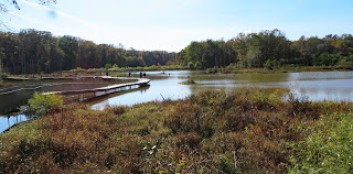
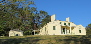
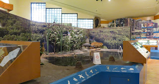
    The Nature Center is accessible. The trail around the pond is accessible. The trail to the house is hardpacked dirt and asphalt in poor condition and not marked well. Visitor with mobility issue should drive to the house. The brick road to the house from the small parking lot is steeply uphill. We did not tour the house interior but it looks like the first floor is accessible. We did not take the trail from the South Kings Highway parking lot.
 The parking lot at the Nature Center is small and may fill on the weekends. Large RVs may not fit.  The South Kings Highway parking lot is small with only one entrance/exit. It may be possible to park smaller RVs by backing up over the grass. Park  38.75778, -77.09856