Sunday, March 31, 2024

Santa Rosa Lake State Park

New Mexico state park campgrounds are among the most reasonably priced in the country and a day fee is not added onto the campsite price. New Mexico is also one of the few states that offers a yearly campground pass to non residents. It's a bit pricey at $225 but worth if you plan to spend time in New Mexico. We haven't stayed in many New Mexico state parks but we've found them to be nice although a bit on the primitive side which is a plus in our opinion. 

Santa Rosa Park has three campgrounds that sit above the lake. Los Tanos is tent only, Juniper Park sites have tables, grills, and shade shelters with water and a dump station nearby, Rocking Point sites are mixed with some having electric hookups along with tables, grills, and shade shelters. Juniper and Rocking Point have restrooms but only Rocking Point has showers. The sites with electricity can be reserved. The accessible site in Juniper Park has water and electric hookups. It also has an accessible table, a paved path to the restrooms, and a large paved parking pad which extends under the table and grill. Rocking Point has two accessible sites but the access to the restrooms are not as good as the site at Juniper.  Most of the sites are not very level. The pull through sites are large enough for most RVs.

 The overlook shelter has a long ADA compliant ramp to the top level. The short paved trail across from the visitor center has a few hills. Most wheelchair users will need assistance. We did not go to the visitor center. 

RVs can be parked along the road at the overlook. The spaces at the path parking lot are between 30' - 40'. Park  35.03103, -104.67948


Friday, March 29, 2024

Pecos National Historical Park

Pecos Pueblo was continuously occupied from the 1200s until 1838. At its peak in the 1500s several thousand people lived in the village which was perched above the Glorieta Pass. It flourished as a trading center with the Plains Indians to the east supplying buffalo meat and hides; and Rio Grande Pueblos to the west bringing corn, beans, squash, pottery and obsidian. The Spanish made contact with the pueblo in the mid 1500s but they didn't attempt to take control until 1621, sending Roman Catholic Franciscans to convert the Native Americans and Spanish settlers to colonize the land. The community lost 75 percent of its population from Spanish and Mexican encroachment, Comanche attacks, a small pox epidemic and other diseases. In 1838 the few remaining people moved to Jemez Pueblo and the buildings were left to crumble. 

This interpretive sign shows the ghost image of a church built in 1625. It was destroyed in the Pueblo Revolt in 1680 when the pueblos banded together to drive the Spanish from the New Mexico territory. The Spanish didn't return to Pecos Pueblo until 1692. 

From 1914 -1929 extensive excavations of the pueblo site were lead by archaeologist Alfred Vincent Kidder. In 1935 the site became a state monument then, in 1965, a national historic park.  

The visitor center has good exhibits and a theater where a short video is shown. Dirt trails lead to the pueblo remains and the remains of a 1717 Spanish mission church built by the Native Americans. Two more trails located off the pueblo site are also available. The Glorieta Battlefield Trail interprets a Civil War battle fought as the Confederate Army sought to gain control of the Santa Fe Trail and a route to the California gold fields. The South Pasture Loop Trail travels along an old ranch road. A museum in the ranch house, formally a trading post built in 1858, is open to visitors. 

The visitor center is accessible. The trail to the pueblo can be accessed from the parking lot or from the rear of the visitor center. It's also possible to drive to the site. Make sure to get a trail guide at the visitor center. The pueblo trail is hard packed but hilly. Most wheelchair users will need assistance. The church ruins has paths paved with bumpy flagstone. There are some steps but except for one section ramps provide a workaround. We did not go to the museum in the ranch house or on the other trails. 

The parking lot has long bus/RV spaces. Most RVs will fit in the parking lot at the pueblo. Park  35.54991, -105.68633


Wednesday, March 27, 2024

Santa Fe NF Boondocking

After climbing steeply along the side of a mountain, Route 34 reaches a level plateau and travels through grasslands studded with juniper trees. This is national forest land interlaced with dirt roads and shared with cattle ranchers. The dirt roads open many camping opportunities but use caution as some of the roads will be impassable after a rain and most of the soil is soft and silty. Please leave the gates in the position that you found them. 

We wanted a spot for one night so we turned at the first solid road and pull off close to the highway - quiet and peaceful.

Shift down when going back down Route 34 because the road is very steep, narrow, and lacks guardrails.  Forest  35.45206, -105.66834


Monday, March 25, 2024

Homolovi State Park

 The Homolovi archaeological sites in the park preserve four ancestral Hopi pueblos. Two are open to the public via short trails. The area was fairly consistently inhabited between AD 620 - 1400; the park focuses on the later period. The largest pueblo, Homolovi II, had between 1,200 - 2000 rooms and features a paved trail that climbs to the top of a hill overlooking the river valley. Several buildings have been excavated and preserved but sadly artifact collectors have torn up the site and destroyed many of the structures. The ground is littered with pieces of broken pottery and, while it may be tempting to take just one piece, disturbing anything is illegal. 

The park has a small visitor center, an observatory, five short trails, and a campground. 

The visitor center is accessible. The trail to Homolovi II is accessible but very steep so most wheelchair users will need assistance. The trail to Homolovi I is an old dirt road. Since it had recently rained we did not attempt the road. The other trails are not accessible due to the rough, hilly terrain. We did not check out the campground or the observatory. 

The parking lots at the pueblo sites and visitor center have several long RV/bus spaces and a number of long spaces where vans will fit. Park   35.045, -110.65336


Sunday, March 24, 2024

Chloride Boondocking

The Hualapai Indians owned this land when silver was discovered in the 1840s. The Hualapia were not receptive to the miners and didn't allow mining until the 1860 when the US Army was sent to subdue them. A treaty signed in 1870s opened the area to mining and the small town of Chloride grew up among the 75 mines where gold, silver, lead, and zinc ores where pulled from the ground. Chloride is now considered a semi- ghost town with a year round population of several hundred people.

This boondocking spot is located on leveled top of a small hill with a few abandoned pieces of mining equipment. We aren't sure what they are but the ground is clear of any metal scraps that could puncture tires. It's a quiet spot with views of the surrounding mountains.

Route 125 to Chloride is paved. A wide maintained dirt road leads to the road to the boondocking spot. That road is narrow and a bit rough. High ground clearance is not necessary but RVs with long overhangs may scrap bottom. BLM Camping  35.41709, -114.2268


Friday, March 22, 2024

Boulder Beach Campground

 The water level of lake Mead fluctuates from year to year. It hit it's lowest level in 2022 and has been slowly recovering but is still dangerously low. In the past it looks like the beach was only about 1000' from the campground; now it's 3/4 of a mile away. 

This is a pretty campground with many trees and vegetation between the sites. The sites are fairly roomy. It's popular and can only be reserved online or by phone so if you want to camp during the winter make reservations early. Amenities include tables,  fire rings, grills, restrooms, water spigots, paved parking pads, and a dump station. The accessible sites are excellent with wide paved parking pads and pavement that extends under the table and fire ring. They were all reserved when we visited. 

The paved River Mountain Loop Trail which parallels Lakeshore Road can be accessed from the campground. We chose to walk/roll along the 1.5 mile Boulder Beach Front Road for a quieter and more scenic hike. Boulder Beach Access Road which leads to the Front Road is fairly steep so most wheelchair users will need assistance.  Campground  36.03618, -114.8026


Sunday, March 17, 2024

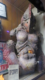
Tom Devlin's Monster Museum

 Tom Devlin dropped out of high school in 2001 and moved to California to learn how to do special effects makeup. After a short course he was given an internship and was soon doing makeup on the TV shows X Files and CSI Miami. During his career in Hollywood he worked on more than 160 feature films making creatures and doing special effects makeup.

Burnt out on Hollywood, he moved to Boulder City, Nevada and opened the Monster Museum in 2017. Almost all of the monsters have been created by Devlin using the originals as a guide. Many of them are from classic horror films like Frankenstein and the Mummy but there are more recent ones like Freddy Krueger and Pennywise, the clown. Although visitors are not allowed to touch the monsters, it's possible to get close enough for photos. I would have liked to see more on how the monsters were created and the makeup processes used in movies. There's a theater where several documentaries are shown. We watched one on the makeup and costumes for the Planet of the Apes movies and plus part of a documentary about makeup artist, Tom Savini. 

 
The building has a ramp but the area of the parking lot that must be traversed to get to it is in poor condition. The first section of the museum is very dark and the hall is narrow. I think most wheelchair will fit with care, We could not read the signs in this section. The rest of the museum is better lit and roomier. In the theater, the best place for wheelchair users is behind the last row of seats. 

The parking lot is too small for large RVs. It may be possible to park at McDonalds or the shopping centers northeast of the museum. Museum  35.97156, -114.85067


Thursday, March 14, 2024

Needle Mountain Road Dispersed Camping

Back on the road! This is a convenient overnight stop. Camping spots are limited with a medium size clearing close in and a large clearing about 1/2 mile farther down the dirt road. There was plenty of room when we stopped but it may be a different story in November. A local off road group holds a charity event in the middle of the month.  Desert Tromp Looks busy!  Camping  34.71906, -114.4358