Showing posts with label WEST VIRGINIA. Show all posts

Saturday, October 19, 2024

Wheeling Heritage Trail

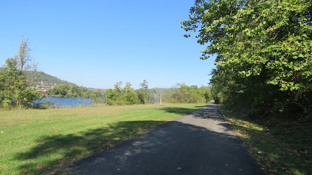
 The Wheeling Heritage Trail follows the Ohio River for 16.5 miles along an old railbed and connects Wheeling, West Virginia to Wellsburg, West Virginia.  We parked north of Wheeling and walked/rolled north towards Wellsburg. After about 1.5 miles of traveling through a green corridor beside the river the trail climbed to parallel Route 2. We turned around as this point and went south, passing our parking spot and going through downtown Wheeling before turning around again to make a total distance of about 6 miles.

The section of the trail that we were on is very urban. If we do this trail again we'll start at Wellsburg and go south. Google satellite view shows that part of the trail farther away from the highway with less developement. 

The trail is in good condition and the only hill we encountered was the section climbing to Route 2.9

Most of the parking areas along the trail are not suitable for large vehicles. We parked at west end of 5th Street where it meets the trail. The parking area is gravel with plenty of room to park and turn around an RV. 5th Street is steep but navigable by any vehicle. Trail     40.07814, -80.72694


Monday, October 23, 2023

Seneca Rocks and Seneca Shadows Campground

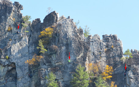
The jagged  ridge of Seneca Rocks, jutting out of the thick foliage covering the rest of the mountain, dominates the view in the flat Potomac River valley. The sheerness, hardness, and height of the rock face draws rock climbers from all over the country. It's the only place in the eastern US that offers this kind of climbing challenge. For able bodied hikers there is another much easier way to the top of the rocks - a 1.3 mile trail that switchbacks up 700' to an observation platform. 

    Red arrows point to three climbers on the rock face. Yikes!

Seneca Rocks is managed by the National Forest Service. It features trails, a visitor center, a pioneer homestead, and a picnic area. Seneca Shadows Campground is located a few miles south. Amenities include tables, fire rings, restrooms, potable water, and a dump station. The terrain is hilly so few of the sites are level. The self-service pay station and the dump station (extra $7 fee) are kind of hard to find -almost at the end of the campground road. Look for signs for the turn. The Recreation.gov reservation site indicates that most of the campsites are first come/first serve but we found many of them had reserved tags on the posts. There were still enough open sites for people who didn't reserve a site. 

The visitor center, which is accessible, has a few exhibits and a nice view of the rocks. A paved, accessible trail switchbacks down to a bridge over Seneca Creek and to the parking lot for the Seneca Rocks trailhead. The pioneer homestead is located at the north end of the lot. The homestead is not accessible due to the rough terrain and lack of a ramp at the house. 
 
The campsites parking pads are paved but very narrow. Some of the sites are marked as accessible on the reservation site but none of them are and the posts at the sites do not have an accessible designation. The double sites are accessible only because they're made wide enough to fit two units which is reflected in the much higher price. We looked for the most level site which was one with steps up to the table. It was also too narrow to deploy my lift. Campground 38.82798, -79.38656


Friday, October 20, 2023

New Deal Homestead Museum

Arthurdale, West Virginia was the initial project of the Subsistence Homesteads Division, part of the President Roosevelt's New Deal agencies. Construction started on the 165 house community in 1933 at the height of the Great Depression with a goal of providing modern, safe living conditions for unemployed farmers, miners, and their families. The community was designed to be self governing and self sufficient with an administration building, community hall, forge, school, post office, stores, and businesses. Each house had a large plot of land so that the families could grow their own food using shared farm equipment. 

This was a pet project of Eleanor Roosevelt, who was very involved in the planning and visited the community 33 times. She also convinced businesses to open factories in the town. Unfortunately, none of them lasted long.Twenty nine communities, located all across the country, were constructed by the division before it was abolished in 1937 because it wasn't popular with either political party and the communities didn't live up to expectations. Even so Eleanor Roosevelt and families living in Arthurdale considered it a success because of the improvements in people's lives. 

Guided tours are the only way to see the museum buildings which consist of the admiration building, the forge, a few outbuildings, one of the houses furnished circa 1930s, and the community hall. The tour is very interesting. A map is available if you want to take a driving tour of the community. Most of the houses are still standing and occupied although many have been remodeled. I highly recommend using the map because we tried just driving around and kept hitting dead ends. 

The administration building, where most of the exhibits are located, and the community hall, which is empty except on special event days, are accessible. The entrance to the house has a high threshold and the second floor is accessed by stairs only. Assistance may be needed to see the outbuildings due to rough terrain.

The parking lot is large enough for RVs. Museum  39.49481, -79.81564


Saturday, October 22, 2022

West Virginia Botanic Garden

Tibbs Run Reservoir supplied clean drinking water to Morgantown, West Virginia from 1912 until 1969 when upgrades in the water system meant the small pond was no longer needed. Locals came to have fun fishing, swimming, and picnicking until city drained the pond in 1980. The land has been leased to the garden, which is a work in progress, since1999.  Most of the planned gardens are located in a small area near the lower parking lot. The rest of the garden has been left natural - a mixed deciduous, hemlock, and rhododendron forest; and wetlands created when the pond was drained.


The garden is accessible with assistance. Park in the lower lot to avoid the steep Hillside Trail from the upper lot. The crushed stone trail from the lower lot to the Reservoir Loop Trail, the only trail designated as accessible, is fairly steep and most wheelchair users will need assistance. The trail itself is level and composed of hard packed crushed stone. The seven other trails are each under 1/2 mile in length but not accessible due to the terrain or trail conditions. Mason Dixon Rifle Club is adjacent to the park so you may hear gunshots. We visited on the weekend and the shooting was pretty constant.

The lower lot is large enough for RVs if parked parallel to the road. Garden  39.6293, -79.86785