Saturday, October 19, 2019

Missouri Civil War Museum

   Under the Missouri Compromise of 1820 states would be admitted into the Union in pairs – one free and one slave thus both Maine and Missouri got statehood status in 1820. All states above the Mason Dixon line would be free; all states below the line would allow slavery, however, when it came time to make Kansas and Nebraska states both were above the Mason Dixon line. The Kansas Nebraska Act of 1854  repealed the Missouri Compromise and allowed the citizens of each state to vote for freedom or slavery. The act further divided the nation and pushed it closer to civil war.

    During the Civil War Missouri was one of the border states- states that condoned slavery but did not leave the Union - and for a while it even had two rival governments.  Anti-slavery "Free-Staters" from Kansas and pro-slavery "Border Ruffians" from Missouri crossed into their neighboring state to raid, fight, and kill each other. The museum gives a broad overview of the buildup to the war and explores different aspects of life during the war for both soldiers and civilians. Short videos fill in the gaps left by the exhibits which contain many artifacts but fall a little short on information.
   The museum is accessible.

   The parking lot is large enough for RVs but has just one entrance/exit. Visitors who are towing may wish to park along one of the side streets. Museum 38.50619, -90.28419
https://www.google.com/maps/d/edit?mid=1H9cnR7qQK955bbLwxdVyKLF384o&msa=0&ll=38.5063540758334%2C-90.28429775605787&z=18

Friday, October 18, 2019

Cedarhurst Center For The Arts

  Artwork from the museum’s permanent collection is displayed in one large gallery. Smaller galleries feature changing exhibits. The family gallery has fun hands-on exhibits for kids to enjoy. Seventy-two sculptures are located on the grounds.
   The museum is accessible. Due to cool and windy weather we did not attempt to see the sculptures. Many are located in the grass and there isn’t a paved trail so they are not very accessible. A few can be seen from the road and the museum walkway.
   RVs will fit if backed up over the grass or parked across the spaces. Museum  38.32745, -88.92121
https://www.google.com/maps/d/edit?mid=1Jw7E-iLZxpm8I02F0NRKtXry6F8&msa=0&ll=38.328089429063006%2C-88.92318624591246&z=17

Thursday, October 17, 2019

Frazier History Museum

   Kentucky has just the right natural resources for making high quality bourbon whiskey – pure water filtered through the limestone shelf; rich soil to grow corn, rye, malted barley, and wheat grains; and oak trees for the aging barrels. Most of the third floor of the museum is dedicated to the history of whiskey making. There’s also an interesting exhibit on the Louis and Clark Expedition which focuses on the members of the expedition and the Native American tribes that they met as they traveled west.
  The first and second floor exhibits include the role of Kentucky as a border state in the Civil War, the tradition of music making in Kentucky, and the permanent collection with artifacts from around the world. A large collection of exquisitely modeled and painted tiny metal soldiers fill cases scattered around the museum.
  The museum is mostly accessible. The Louis and Clark exhibit has question sections with the answers behind little lift-up panels. The panels can not be reached from a seated position.
   We parked in the lot at the corner of 9th Street and Washington Street. There’s room for RVs but I think that we were charged the bus rate – $18.00. The sidewalk to the museum is in good condition but the hill is steep. When we drove west out of town we found both metered and free on-street parking along West Main Street. This is an industrial area rather than a tourist area and it’s just a few blocks from the museum. I recommend parking on the street rather than in the lot. Museum  38.25759, -85.76452
https://www.google.com/maps/d/edit?msa=0&mid=19zg0FRFxunit8Sk-Mg_QhfuOvww&ll=38.25806768408309%2C-85.76505220672863&z=18

Wednesday, October 16, 2019

Muhammad Ali Center

   Neither of us are fans of boxing but we admired Ali’s zest for life, his dedication to his beliefs, and his quick witted humor so this museum was a good place to learn a little more about him. The museum covers Ali’s life starting from from his childhood in Louisville,Kentucky then moving through his early boxing career, his conversion to Islam, his refusal to be induced during the Vietnam War, his comeback in 1970, retirement in 1981 and finishing with the 1996 Olympics when Ali, suffering from Parkinson’s disease, slowly made his way across the stage to light  the Olympic cauldron.
   The museum is accessible.
   Parking for RVs is limited in Louisville. We found a handicapped parking spot on 8th Street, a few blocks away from the museum. RV parking may be possible at the Wharf LotMuseum 38.25804, -85.76023
https://www.google.com/maps/d/edit?msa=0&mid=19zg0FRFxunit8Sk-Mg_QhfuOvww&ll=38.258263743473144%2C-85.76037499105377&z=19

Tuesday, October 15, 2019

Bob Evans Farm Museum

  “Bob Evans down on the farm” We all know that ditty from the TV commercials however Bob Evans’s first venture was a steakhouse in Gallipolis Ohio. It was opened 24 hours and catered to truckdrivers. Sausage was on the menu but in 1946 sausage was made with scrap pieces of meat, fat, and tendons. It wasn’t very tasty so Bob Evans began making his own using all of the good meat from the hogs. The sausage was a big hit.

   A group of eight family members and friends were involved in the sausage business and bought the farm in 1953. Bob and his wife, Jewel, lived in the 1825 brick farm house which was the setting for many commercials starring Bob, Jewel, and their six kids.
   The house now serves as the museum. All of the rooms, except for the kitchen, have been gutted and the walls are covered with photos and text. Continuous sausage commercials run on an old television and Bob and Jewel show off their products in the kitchen.
    In addition to the house, five log buildings have been relocated to the property and are opened to tour. The interiors are furnished with items appropriate to the 1800s and early 1900s.
  The museum is accessible. One of the cabins has a ramp and it appears that the others will get them eventually. The road is rough gravel and wheelchair users will probably need assistance.

   Bob Evan’s early commercials invited people to come down to the farm and to accommodate everyone who took him up on the offer, a small restaurant, the Sausage Shop, was built on the property. The Sausage Shop is long gone but there is a modern Bob Evans Restaurant.
   The main parking lot is for the restaurant and there isn’t room for large RVs. One long bus/RV space is located along the museum road. RVs up to 35’ will fit in the end spaces of the museum lot.

   Every October a festival is held on the farm with live performances, shows, demonstrations, and fall food treats. RVers are welcome to camp in the fields at no charge. Preparations for the festival had already started, a full week in advance, when we visited. Museum  38.88204, -82.36754

https://www.google.com/maps/d/edit?mid=1KXa9y13g6eCNgXHR2ihNeRlHhq0&msa=0&ll=38.88331085256909%2C-82.37309806396593&z=14


Sunday, October 13, 2019

Point Pleasant Riverfront Park

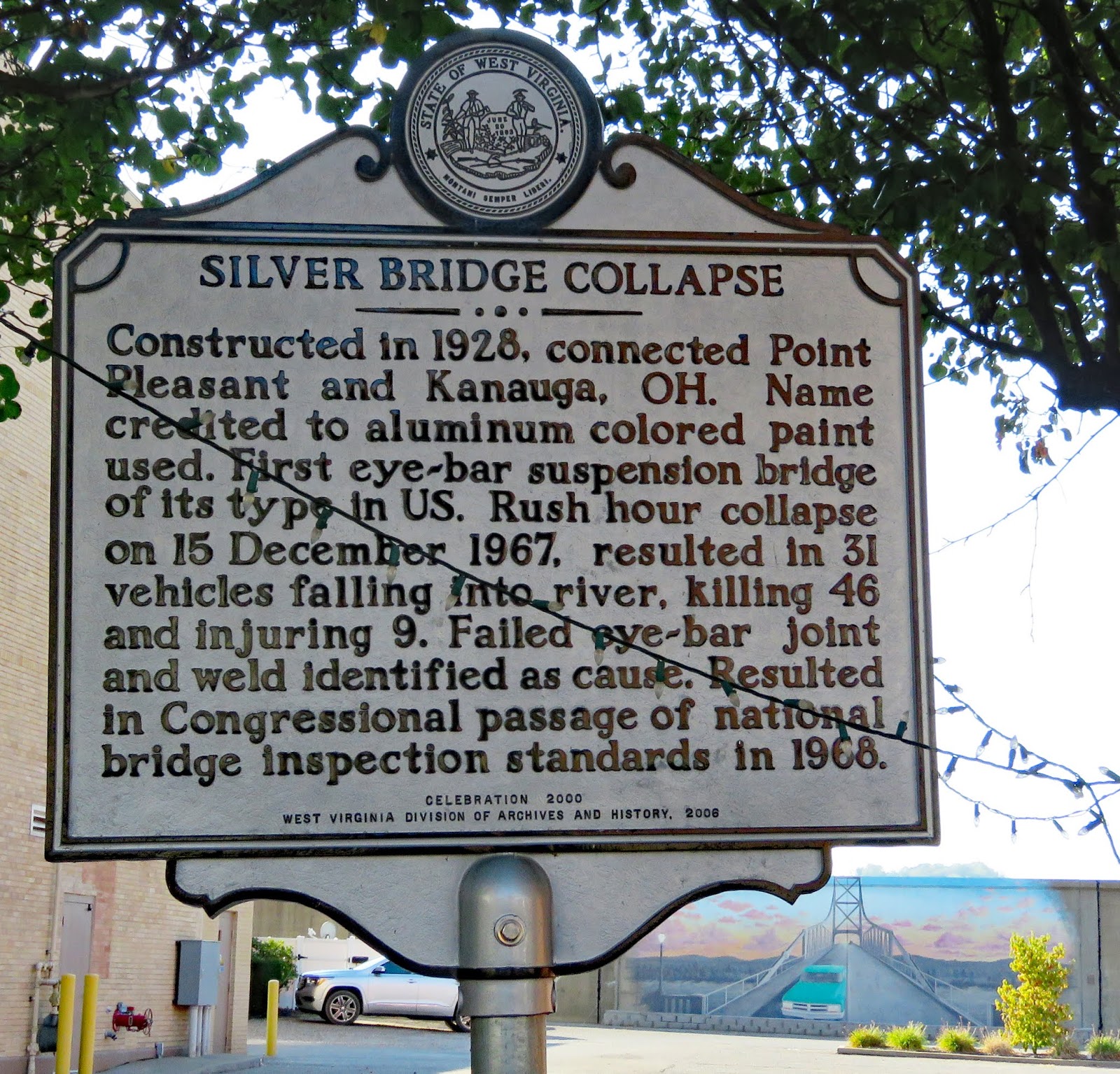
   Murals depicting the history of Point Pleasant stretch along the river side of the floodwall. There are also several large stainless steel sculptures created by local artist Bob Roach and a few interpretive signs. A mile long trail follows the river. The location of the Silver Bridge which collapsed on December 15, 1967, killing 46 people and injuring 9, can be viewed from the trail. A replacement bridge, the Silver Memorial Bridge, was built about 1 mile downstream.
   The park is accessible. A very short section of the trail is paved. The rest is surfaced with rough gravel and is not accessible.

     RVs can be parked on the surrounding streets. We parked in a lot on the corner of Main and Third. The sidewalk curb cuts are steep. Park 38.8428, -82.13964
https://www.google.com/maps/d/edit?mid=1857yydH4SZna335kTyKSpwrM5FQ&msa=0&ll=38.842802244943925%2C-82.13978755401052&spn=5.105509%2C7.415771&z=20

Tu-Endie-Wei State Park

   Tu-Endie-Wei, meaning “point between two waters” in the Wyandotte language, is located where the Kanawha River joins the Ohio River. The park commemorates the 1774 battle between Virginian settlers and Shawnee and Mingo warriors. The Native Americans lost the battle and the Ohio River became the border between their land and British territories.
   A large log house built in 1796, originally used as an inn and later a home, is now a museum.
   A paved path leads to the battle monument and the log house. One room of the museum is accessible. The other rooms all have steps.

   RVs can be parked on the street in front of the park. Park 38.83919, -82.14029
https://www.google.com/maps/d/edit?mid=1857yydH4SZna335kTyKSpwrM5FQ&msa=0&ll=38.839568721309725%2C-82.14068468477933&spn=5.105509%2C7.415771&z=18

Saturday, October 12, 2019

Mothman Museum

  The ability to suspend your grasp on logic and reality will enhance your enjoyment of this museum. ;-) In November 1966 two young couples were driving around the abandoned site of a former World War II munitions plant when they saw a large flying man with ten-foot wings. Over the next year the creature was also spotted by six gravediggers, two volunteer firemen, and numerous area residents.

   The mothman was deemed a harbinger of doom when tragedy struck on December 15, 1967. A poorly designed bridge which spanned the Ohio River collapsed killing 46 people and injuring 9. The mothman sightings stopped.
   The  mothman myth probably would have faded to obscurity had it not been for a 2002 movie, the Mothman Prophecies, starring Richard Greer. The town of Point Pleasant seized the opportunity to revitalize its downtown and later that year held the first Annual Mothman Festival which has grown to attract over 10,000 people.
   The museum features first person accounts of the sightings, newspaper clippings, movie memorabilia, a video about the bridge, and full sized figures of the mothman and the mysterious men in black who appeared in town at the same time. A statue of the mothman is located on the street across from the museum.
   The museum is accessible but the sidewalk slopes up to the entry door which opens outward making entering awkward.
   RVs can be parked on the street. We parked in a lot on the corner of Main and Third. The sidewalk curb cuts are steep. Museum   38.84265, -82.1386
https://www.google.com/maps/d/edit?mid=1857yydH4SZna335kTyKSpwrM5FQ&msa=0&ll=38.842792666896365%2C-82.13881274274786&spn=5.105509%2C7.415771&z=19