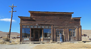
Gold was discovered in Bodie in 1859 but the town’s growth was slow until 1875 when a mine collapse exposed a rich vein of ore. During it’s most productive period, from 1877 – 1881, the town had 30 mines, nine stamp mills, 60 salons, and around 8,000 people. News of gold strikes in Arizona, Montana, and Utah lured many miners away but Bodie’s mines stayed active until the last one closed in 1942. Caretakers watched over the deserted town until 1962 when California State Parks bought it.
This is one of the best-preserved ghost towns in the US. Most of the buildings fell prey to fire and decay but the 5% that survived are in wonderful condition. The interiors remain as the last occupants left them with miscellaneous furniture, stocked shelves, and stacks of school books.
Get a walking tour brochure at the visitor center or the red barn. There are 50 stops on the tour. A video about the town runs continuously at the red barn. When we visited the Miller house and the Methodist church were opened. The visitor center was not opened. The mill buildings and surrounding area are open for tours during the summer only.
Attempts have been made to provide accessibility however most visitors in wheelchairs will still need assistance. The path that goes downhill from the parking lot to the townsite is concrete. The main streets are hardpacked. The red barn is accessible. During the summer arrangements can be made to drive to the barn and borrow a balloon tired wheelchair. The Miller House and Methodist church are not accessible due to steps. The visitor center has a ramp and boardwalk. Peeking in the windows of the buildings is difficult because of the window height, uneven ground, and other obstacles.

The park is thirteen miles east of US 395 on Bodie Road. The first 10 miles are narrow but paved. The last three miles are washboard dirt – very rough but worth the trip. Parking for RVs is limited to the side of the road past the main parking lot. Since it wasn’t busy when we visited we parked in the main lot and got permission from a park ranger. The road to the park is closed after the first heavy snowfall.
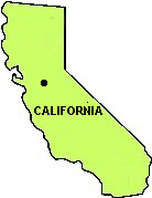
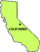
Bodie 38.21343, -119.01504


 The desert signpost, abandoned gas station and graffiti wall, and the shoe fence are on a 15 mile stretch of California 62 to the west of the non-existent town of Rice.
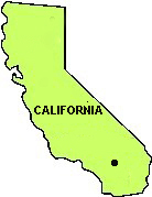
 The lot designated for overnight stays is in the northeast corner. It has a slope so leveling may be needed. Check-in at the security desk is required.


 The ground is mostly hard packed sand but some areas on the outskirts are soft and hard to push through.