Central School was built in 1894 and through the years served as an elementary school, junior high and high school, and even as a community college but after sitting empty for a few years it was scheduled for demolition. Fortunately the City of Kalispell decided this beautiful example of Richardsonian Romanesque architecture was worth saving especially since the tin ceilings, wainscoting, and hardwood floors were still in good condition.
The first floor of the museum is dedicated to Native American history and artifacts; and the life story of Frank B Linderman. Linderman left his home state of Ohio in 1885, at just sixteen years of age, to become at trapper in Montana territory. Over the next six years he lived on Native lands and became friends with the Salish, Kootenai, Crow, Blackfeet, Cree, and Chippewa. He learned tribal customs and legends. His interest in the tribes continued after he married, had a family, and worked as an assayer, furniture salesman, newspaperman, insurance salesman, and politician. After he retired he wrote over 20 books, fiction and nonfiction, about Native Americans and frontier life.
The second floor has exhibits on the logging industry and the Flathead Lake area, both before and after the dam was constructed.
An accessible entrance is on the north side of the building. The museum is accessible.
RVs can be parked on the street on the south side of the museum – free, two hour parking. Museum 48.19731, -114.3104
Thursday, August 22, 2019
US-2 Bear Creek Boondocking
The only thing we dislike about this spot is how close it is to US 2. Other than that it’s just about perfect – level, beautiful scenery, beside a creek, a choice of sun or shade, and a 16 day camping limit since it’s on Flathead National Forest land. No AT&T signal though.
More intrepid campers may want to continue down the road for a short distance to a large, rocky, and more secluded campsite that is almost circled by the creek. The road is narrow and has a constant stream of water running across it which causes potholes. We walked/rolled to the campsite and decided that the creek bank was too unstable for our heavy RV. Someone has dumped several loads of gravel to shore it up and make it safe for smaller, lighter vehicles. Forest 48.24878, -113.47146

More intrepid campers may want to continue down the road for a short distance to a large, rocky, and more secluded campsite that is almost circled by the creek. The road is narrow and has a constant stream of water running across it which causes potholes. We walked/rolled to the campsite and decided that the creek bank was too unstable for our heavy RV. Someone has dumped several loads of gravel to shore it up and make it safe for smaller, lighter vehicles. Forest 48.24878, -113.47146
Wednesday, August 21, 2019
Heritage Museum
If the town of Libby, Montana seems familiar it’s probably because of a series of news stories written by a Seattle journalist in 1999. Vermiculite, which is used as an insulation, was first mined in Libby in 1919. The type of vermiculite in Libby mines is contaminated with asbestos but the miners and townspeople were never told to take any precautions. Mining waste was used in playgrounds, backyards, gardens, roads, and the school running track. Work clothes were washed in family homes. An estimated 400 Libby residents have died and almost three thousand became sick from diseases caused by the asbestos.
The mines closed in 1990 but cleanup did not begin until 2002 when the town became a Superfund site. $425 million has been spent to remove contaminated soil, mine waste, and attic insulation. The asbestos infiltrated the entire area, including the forests, and it will never be possible to clean it all up. People still live there. :-(
The asbestos story is kind of buried in a back corner of the museum and features a timeline of asbestos mining in Libby and videos with the personal stories of Libby residents and how the contamination affected them. Other exhibits cover the history of Libby including railroads, steamboats, logging, mining, and Native Americans. One of most interesting exhibits explains the culture shock young men from Harlem felt when they joined the Civil Conservation Corp and were shipped to camps in the wilds of Montana. Farming and mining equipment, and historic buildings are located on the grounds outside.
The museum is accessible except for the small room of the second story and one exhibit that has a steep ramp. The outside exhibits are not accessible due to lumpy, uneven ground.
The parking lot is large enough for any RV. Museum 48.37223, -115.54363
The mines closed in 1990 but cleanup did not begin until 2002 when the town became a Superfund site. $425 million has been spent to remove contaminated soil, mine waste, and attic insulation. The asbestos infiltrated the entire area, including the forests, and it will never be possible to clean it all up. People still live there. :-(
The asbestos story is kind of buried in a back corner of the museum and features a timeline of asbestos mining in Libby and videos with the personal stories of Libby residents and how the contamination affected them. Other exhibits cover the history of Libby including railroads, steamboats, logging, mining, and Native Americans. One of most interesting exhibits explains the culture shock young men from Harlem felt when they joined the Civil Conservation Corp and were shipped to camps in the wilds of Montana. Farming and mining equipment, and historic buildings are located on the grounds outside.
The museum is accessible except for the small room of the second story and one exhibit that has a steep ramp. The outside exhibits are not accessible due to lumpy, uneven ground.
The parking lot is large enough for any RV. Museum 48.37223, -115.54363
Tuesday, August 20, 2019
Yaak River Campground
A thick forest and lots of low brush provides plenty of privacy in the two loops of this national forest campground. The loops are located on both sides of the Yaak River where it meets the Kootenay River. Most of the sites are level. Seven are pull through and long enough for class As.
None of the sites have signs identifying them as accessible but we saw three or more that are. The one that we chose, # 37, is close to the vault toilet and almost level with a paved path to the extended top picnic table. Campground 48.56293, -115.97581

None of the sites have signs identifying them as accessible but we saw three or more that are. The one that we chose, # 37, is close to the vault toilet and almost level with a paved path to the extended top picnic table. Campground 48.56293, -115.97581
Monday, August 19, 2019
Pend Oreille County Museum
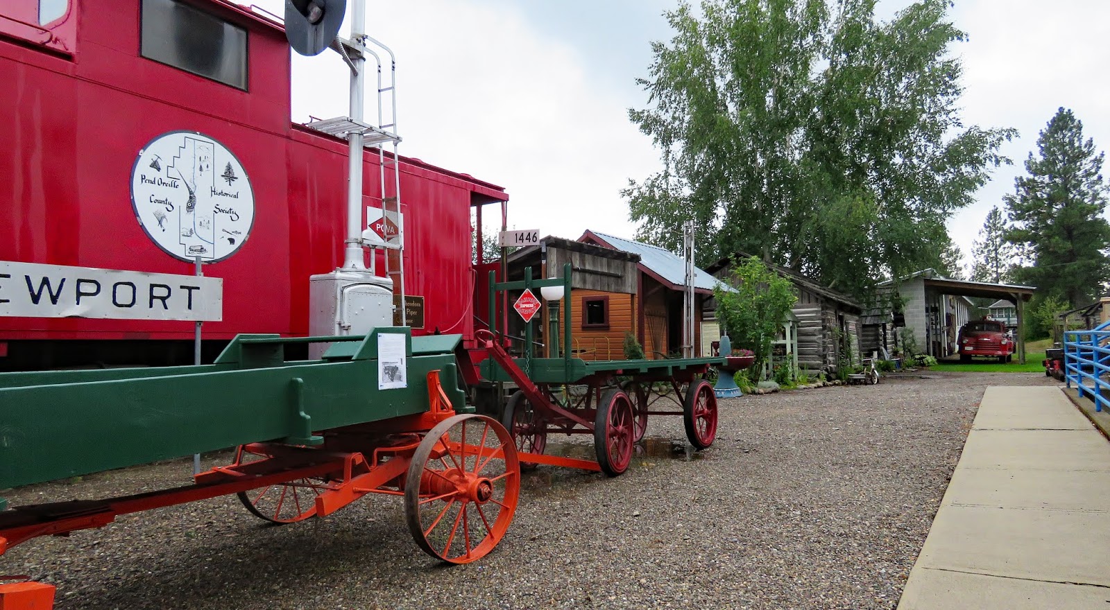
It seems like the local people saved everything and most of it ended up in this museum. ;-) All of the items are neatly arranged but there’s very little information or history provided. The main building is an historic depot. More displays are located in another building and three log cabins, an equipment shed, a fire lookout, a pioneer church, and train cars are located on the grounds.
The depot has a high threshold and the second floor has steps and no elevator. The other building is accessible. The grounds are accessible but the most of the buildings have steps at the entrances.
The parking lot is large enough for any RV. Museum 48.17759, -117.04374
The depot has a high threshold and the second floor has steps and no elevator. The other building is accessible. The grounds are accessible but the most of the buildings have steps at the entrances.
The parking lot is large enough for any RV. Museum 48.17759, -117.04374
Sunday, August 18, 2019
Dragoon Creek Campground - DNR
Stop at the information kiosk after entering the park and grab a registration form. The form allows the state to keep track of how many people visit the park.
The campground has two roads but only the right road has a camping sign. Check the left road if you don’t find anything suitable on the right road. Some sites are large enough for any RV and some sites have access to a swimming hole in Dragoon Creek.
The accessible site is excellent with a paved parking pad, a paved path to the vault toilet, and a paved path to a covered picnic table. There’s also a raised tent platform which doesn't have a connecting paved path. Campground 47.88829, -117.4421
Milk Bottle Building #1
RVs can be parked on 4th Ave or in the adjacent lot after business hours. The bottle can also be viewed without leaving your vehicle. Bottle 47.65276, -117.43232
Saturday, August 17, 2019
Manito Park Gardens
Manito Park is a Spokane city park with five small themed gardens, two playgrounds, a conservatory, and a small pond. The roads do not have sidewalks and the trails are hilly and rough. Most people just walk along the roads since there’s little traffic.
The gardens are located fairly far apart from each other so visitors with mobility issues may chose to drive to each one. Each garden has a small parking lot where shorter RVs will fit. Most have an accessible entry path. The Japanese Garden, Rose Garden, Duncan Garden, conservatory, and pond all have paved or gravel accessible paths with a few minor obstacles such as short steps or hills. The Lilac Garden and the Perennial Garden do not have paved paths but can be viewed from the road.
RVs will fit in the lot by the Japanese Garden and the lot to the east of the Duncan Garden. There’s also on-the-street parking along 18th Ave and Tekoa St. Park 47.63614, -117.41496
The gardens are located fairly far apart from each other so visitors with mobility issues may chose to drive to each one. Each garden has a small parking lot where shorter RVs will fit. Most have an accessible entry path. The Japanese Garden, Rose Garden, Duncan Garden, conservatory, and pond all have paved or gravel accessible paths with a few minor obstacles such as short steps or hills. The Lilac Garden and the Perennial Garden do not have paved paths but can be viewed from the road.
Northern Quest Casino
We parked in the far end of the southern lot where other RVs were parked. Security stopped and marked down our license number but did not talk with us or leave any flyers.
From the parking lot follow the crosswalks to the right side of the casino complex to get to the casino entrance. The casino is accessible with fairly easy to move chairs and easy to reach money and card slots. Casino 47.65618, -117.56358
| Pass |
Friday, August 16, 2019
Ankeny #1 Campground - WDFW
We’ve camped at several Washington Dept of Fish and Wildlife fishing areas and they’ve all been very primitive - just a spot to park near a lake – but this one has a vault toilet, graveled parking pads, and, something we never expected, an accessible, paved parking pad with a paved path to the toilet.
We chose to park on the gravel instead to get a nice view of the lake. Very quiet and almost empty on a Friday in August.
The camping area is large enough for any RV. Campground 47.63967, -119.32206
We chose to park on the gravel instead to get a nice view of the lake. Very quiet and almost empty on a Friday in August.
The camping area is large enough for any RV. Campground 47.63967, -119.32206
Subscribe to:
Posts (Atom)