Wednesday, July 23, 2025

Mascall Overlook - John Day Fossil Beds

 
The John Day River basin is about 100 square miles in total with three widely separated areas managed by the national park service. These areas protect fossils of plants and animals that were covered by ash, dust, and floods from multiple volcanic eruptions occurring over a time span of 40 million years. The layers of rock form an almost continuous history of the plants and animals that lived in Pacific Northwest after the era of dinosaurs. 
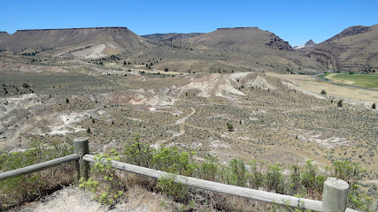
The Mascall Overlook view is of the one of the newest layers consisting of stream-deposited volcanic tuff that preserves fossils of horses, camels, rhinoceroses, bears, pronghorn, deer, weasels, raccoons, cats, dogs, and sloths plus oak, sycamore, maple, ginkgo, and elm trees. 

 
A short gravel trail leads to the overlook. The gravel is loose so wheelchair users may need assistance

Parking for RVs is located along the edge of the parking loop.  Overlook   44.50061, -119.62208
 

Tuesday, July 22, 2025

Kam Wah Chung and Co. Museum

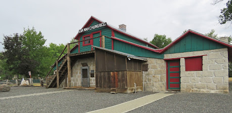
The quest for gold drew Chinese men to the John Day area. Several 100 settled in a crowded community on the western edge of town including two friends, Ing "Doc" Hay and Lung On, who arrived in 1888 and set up shop in a rambling structure that was originally built in the1860s as trading post and stage coach stop. Lung On operated a general store in the building  and "Doc" Hay was a practitioner of herbal medicine.  The two men stayed on even after the miners left and after most of the buildings in the Chinese community were destroyed by fire.

 "Doc" Hay and Lung On became very successful. Doc Hay was well respected by both the local Chinese and non-Chinese communities and people came from all over  Oregon to be treated. Lung On invested in timber, mining, rental properties, and opened a car dealership in John Day.

Lung On died in 1940 then in 1948 "Doc" Hay broke his hip. He locked the store before going to a hospital in Portland. He thought he would be back in a few weeks but never recovered enough to return and died 1952. The building was untouched until 1967 when a local councilman began a campaign to make it into a museum.

This place is so cool. The contents of the building are almost exactly the same as when it was closed in 1948. Nothing has been added and very few things have been removed. 

A little planning is required to visit the site as it's only open on  Fridays, Saturdays and Sundays May through Oct but it's well worth it. This is the first time that we've been in John Day, Oregon on a weekend so we were happy that we would finally get to visit. The store is opened for guided tours only so stop at the museum to sign up. The museum has excellent exhibits on Chinese emigration, life in the US, and the Kam Wah Chung store.
The museum has a ramp to the entrance and is accessible. The parking lot is partly paved and partly gravel. Park close to the building to avoid the gravel which is deep and loose. The store is a short walk/roll along the sidewalk and street or a drive if preferred. A movable ramp is put in place to access the small step up onto porch of the store. A threshold between two of the interior rooms is a little high. The store is a bit cramped but most wheelchairs will fit. 
The parking lots are large enough for any vehicle.  Museum   44.41737, -118.95554
 

Sunday, July 20, 2025

Black Rock Meadow Boondocking

We stopped here to just eat lunch but it looks like a great place to boondock. There's a large open area surfaced with dark rock and a grassy meadow with evergreen trees. A network of forest roads can be accessed from the site. Boondocking  44.62465, -118.46423


Saturday, July 19, 2025

National Historic Oregon Trail Interpretive Center

The interpretive center sits high up above the Virtue Flat valley overlooking the wagon ruts of the Oregon Trail. The valley is wide enough that the wagons could spread out and follow different paths. One of them is still easy to see. Get a closer look by following the trail that starts at the visitor center or the short trail off of Route 86.

 The exhibits in the interpretive center are excellent and allow visitors to follow the journeys of the travelers on the trail from their initial planning to their challenges with homesteading in Oregon. Kids can  plan their own journeys in an interactive area. 

The interpretive center is accessible. There are two miles of accessible paved trails that we didn't take because of the summer heat. Several short unpaved trails may also be accessible. An outdoor display of various types of wagons is accessible. The trail to the wagon ruts on Route 86 is partly accessible. The paved section ends abruptly and becomes rough gravel.  

 
The parking lot has long RV spaces. It was slow day for visitors so we parked closer to the center to avoid a uphill roll.  Center   44.8133, -117.72712
  

Friday, July 18, 2025

Hells Canyon Info Wayside

As we rolled south from the little town of Halfway, Oregon, on our way to a BLM boondocking spot, we drove past a sign for the wayside and turned around to check it out. It's just a large gravel lot with an information kiosk and an old mine car for historic interest. And shade! :) There aren't any "no overnight parking" signs and we had a peaceful night's sleep. 44.86023, -117.09271 


Thursday, July 17, 2025

Evergreen Campground

We were hoping for some shade on a hot summer day but all the tree covered sites were taken so we ended up in site 7 with only a few bushes which didn't help at all. Fortunately it cooled off nicely in the evening.  

Site 7 appears to be a double site but it's not marked as such on the post, at the fee station, or on the national forest website so we paid the single fee. It has a wide paved parking pad and hard packed gravel around the high fire ring and two tables with extended tops.  Of the seventeen sites, eight are designated as accessible which is very unusual. Five can be reserved. 

Amenities include vault toilets and fresh water from a pump. No trash cans or cell service. The campground is right off of  US 95 which has a lot of truck traffic that continues into the evening and starts again in early morning. The Weiser River Rail Trail can be accessed from the campground. It's a rough gravel trail so we did not try it. Campground  44.89224, -116.38885


Tuesday, July 15, 2025

White Bird Battlefield Overlook

The overlook is on a hill above the White Bird Battlefield where a Nez Perce band made camp as they sought to avoid US soldiers who were to escort them to a reservation. On the morning of June 17, 1877, as the cavalry approached the camp, six Nez Perce came towards them holding a white flag.  Against orders, one of the soldiers fired on the Nez Perce. Warriors who had been concealed by the high grass returned fire.The battle that followed resulted in the death of 34 soldiers and forced the cavalry to retreat, leaving an escape route for the Nez Perce. 

The battle started Nez Perce on a 126-day, 1,170 mile journey toward Canada.They were only forty miles from the Canadian border when  soldiers surrounded them on October 5, 1877. Freezing and hungry, they were forced to surrender and settle on reservations. 

The overlook has a shelter and several interpretive signs. Everything is accessible.

The parking lot is large enough for any vehicle. Overlook  45.80191, -116.2871


Monday, July 14, 2025

US Route 12 Lolo Pass

The Lewis and Clark Expedition reached the beginning of the trail across the Bitterroot Mountains in mid September 1805. Snow already covered the mountain tops but they had no choice but to continue because the pass wouldn't be clear of snow until the next summer. The 200 hundred mile trek took eleven days. They had to kill and eat several colts because there wasn't any game. The horses suffered from lack of forage and water and often fell and slid down the steep, rocky hills. This was the hardest part of the expedition's journey and they spent about a week with the Nez Perce tribe at Weippe Prairie recovering and resupplying.

The trail still exists as a primitive unpaved road built by the CCC in the 1930s - high clearance recommended. Fortunately Route 12, which follows the valley south of the Lolo Trail and winds along beside Lolo Creek and the Lochsa River, was completed in 1962 and is an easy and scenic route through the mountains. 

We drove west along Route 12 from Lolo, Montana to Kooskia, Idaho and made a few stops along the way. Our first stop was just across the Montana/ Idaho border at Lolo Pass Visitor Center. The parking lot has long RV spaces. Exhibits in the center focus on Native Americans and the Louis and Clark expedition. A short paved and boardwalk trail makes a loop though the forest and wetlands. The trail is accessible but the bridge over a small stream does not meet flush with the ground at either end. 

We also walked/rolled along the Glade Creek Loop Trail which I think is a cross country ski trail. It starts out wide and smooth and goes gradually uphill. It becomes narrower and gravely then starts downhill. We turned around at that point because we didn't know how long it was or if the terrain would become more difficult. We stopped back at the visitor center to ask about the trail and I think we could have completed it. Doable with a strong helper. 
Our next stop was at Devoto Grove Trail which is an accessible paved loop trail though beautiful old growth western red cedar trees. The largest parking pull off is on the opposite side of the road. 
 Mountains rise up on both sides of US 12 so we didn't expect to find many accessible trails but we decided to try Warm Springs Trail that follows Warm Spring Creek to Jerry Johnson Hot Springs. The first challenge is a steep downhill then after the bridge over the creek, a steep uphill. The trail starts out wide and smooth and we thought it would be okay but then we hit the rocks. Time to turn around. We gave it our best but it's definitely not accessible. A large parking lot with a vault toilet is on the opposite side of the street. 
We spent three nights along Route 12 - in a pull out, at Powell Campground, and at Knife Edge Campground. There are many pull offs along US 12 and none that we saw are signed "No Camping". Due to the number of people driving along Route 12 and the small size of the forest campgrounds, the pull outs can be a welcome overnight stop if all the campgrounds are full.  

Powell Campground has both electric and non-electric sites. All but ten sites can be reserved so electric sites may not be available. We camped in site 9, one of the few non-electric sites available in late afternoon. We didn't see any accessible sites but many are usable. Amenities include tables, fire rings, and vault toilets. Restrooms with running water and flush toilets are located near the camp host's site. 

Knife Edge Campground does not have a sign indicating that it is open for camping. The only sign is for a boat launch. This may be because the campground is very small and gets heavy use in the spring when the Lochsa River is high. From May 22 to June 30 half of the campsites are closed and the spaces are used for parking. The boat ramp is very rocky and seems like it's made for launching rafts, kayaks, and other small boats. We camped in the first site on the left which is a very long pull though site. We parked sideways for a better view. Amenities include tables, fire rings, a vault toilet, and changing rooms. None of the campsites are designated as accessible but they have tables with extended tops and high fire rings. 

US 12 is a winding road with 50 MPH as the highest speed. There isn't a lot of traffic and the road is suitable for any vehicle. The pull off are long and the campgrounds have spaces long enough for most RVs. US 12 Lolo Pass