Wednesday, November 25, 2020
Ash Meadows National Wildlife Refuge
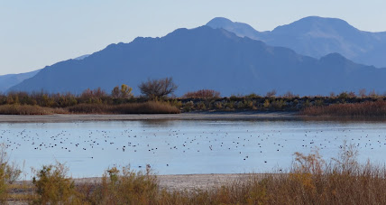
Water that entered the groundwater system thousands of years ago bubbles to the surface in thirty seeps and springs to create a wetland of over 23,000 acres. The refuge has been protected since 1984 but it was almost destroyed in the 1960s and 70s when a portion of land was drained and mined for peat; additional land was drained for hay and alfalfa farms; and plans were drawn up for a housing development. None of these activities and plans were sustainable for long – there is just not enough water. 
The refuge has a visitor center (closed due to conronavirus), three short boardwalk trails, and five roads that are closed to traffic but open for hiking. The best times to see wildlife and unique plants are in spring and fall. Since we visited in the winter the wildlife was scarce but the refuge was still very enjoyable.
The visitor center appears to be accessible. All of the boardwalk trails are accessible. The closed roads at Crystal Reservoir and Rodger Spring are accessible with assistance. The Devils Hole area is not accessible due to rocky ground and steep, narrow trails.
The main roads are suitable for any vehicle but all of them are horrible washboard. The other roads get sloppy when it rains and have ruts. Parking is limited at Peterson Reservoir and DeviIs Hole. I recommend driving in one entrance and out the other to avoid having to go back over the same territory. We came in at the south entrance, saw the sights at that end of the refuge, then boondocked on BLM land outside of the refuge and saw the sites near the west entrance over the next two days. Refuge 36.42376, -116.32818

Friday, November 20, 2020
Snowbird Mesa
Also know as Poverty Flats. Ownership of the piece of land is in question. It’s not BLM land as many people assume. It may be Bureau of Reclamation due to it’s proximity to Lake Mead but the most realist possibility is that it’s private land owned by the Simplot Company which has a silica plant a few miles north. As long as the campers don’t cause any problems Simplot welcomes them to stay. Some people stay for several months in the winter.
There are two separate areas. One is up on the mesa with sweeping views of the highway, mountains, and the town of Overton. The other is a large flat area that looks like the preferred spot for people with long RVs but the slight hill to the mesa top should be doable with most RVs. This place is huge and I can’t imagine that it ever gets to the point of feeling crowded. Snowbird Mesa 36.48502, -114.44556
Monday, November 16, 2020
Parowan Gap Dinosaur Track and Petroglyphs

 A short trail wanders through the rock formations to several tracks. They’re a little hard to spot, in fact, we missed all of them on the trip out but found a lot of them on the way back. Look for the metal dinosaur tracks on poles that mark the easiest to view tracks.
 Saturday, November 14, 2020
FR 281 Boondocking
A large, flat, and easy to access clearing makes this an ideal campsite for a quick stop. Multiple fire rings and an absence of vegetation attests to it’s popularity so it might be a good idea to explore farther along the road for longer stays. Some of the surrounding land is private. Make sure that you are on public land - Forest Map 38.9091, -111.73215
Friday, November 13, 2020
Across Utah on Interstate 70
I avoid interstate highways as much as possible but sometimes I wonder how much beautiful scenery we’re missing by doing that. We’ve driven west from Denver on I-70 and that drive is spectacular but I don’t remember ever going through Utah on I-70. There are no towns or services for over 100 miles between Green River, Utah and Salina, Utah making this stretch of interstate one of the least populated in the country. Check your gas tank before starting. We filled up in Green River which is famous for it’s melons – something about the hot days, cool nights, and sandy soil. The watermelon that we bought was just the right combination of sweetness and juiciness. There are a number of exits to view points with small parking lots. The land along the interstate is almost all BLM land so if you can find a good dirt road dispersed camping should be easy. We saw campers in the distance all along the route. This is a place that merits more exploring on another trip. I-70 38.94194, -109.82163
 There are a number of exits to view points with small parking lots. The land along the interstate is almost all BLM land so if you can find a good dirt road dispersed camping should be easy. We saw campers in the distance all along the route. This is a place that merits more exploring on another trip. I-70 38.94194, -109.82163
Wednesday, November 11, 2020
Needles Overlook Interpretive Site
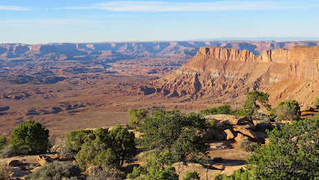
Drive seventeen miles west on narrow Canyon Rims Road until it ends at a small parking lot. Spread out far below is all of Canyonlands National Park, a view that most people don’t see because of the remote location. There is a short paved trail with two overlooks and two dirt trails. The paved trail is accessible but the view from one overlook is partly blocked by the interpretive sign, the other is blocked by railings and concrete that ends a little too soon so it’s not possible to pull up close to the railing. One of the dirt trails is accessible with assistance, the other is too rocky. The views are best with the late afternoon sun because of haziness in the morning. This is all BLM land and designated as a “recreation management area”. I can’t find an explanation for that but it seems to pertain to OHV riding. There are many dirt roads and also many signs prohibiting riding cross country or riding near the overlook area. There are signs prohibiting camping near the overlook area too. We found a large flat spot that had obviously been used before about 4 miles before the overlook area and a few hundred feet from a sign that said “Camping Prohibited Beyond This Point”. There’s also a BLM campground called Windwhistle located on Canyon Rims Road, about 6 miles west from US 191.
Canyon Rims Road is paved the entire way and suitable for any RV. The sites in the campground are large enough for any RV. The overlook area has parking along the side where RVs will fit. Overlook 38.25988, -109.69597
Sunday, November 8, 2020
David Sipe’s Folkart
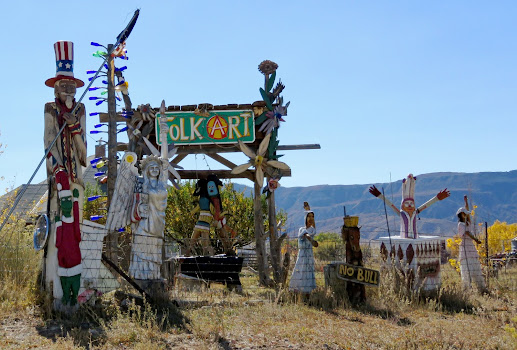
We were driving west on US 160 in Colorado and spotted these carvings on the hillside. We had to turn around to get a better look! David Sipes and his partner Nancy Segel, have been creating art here for about 20 years so there’s a lot to see. When we pulled into the driveway loop Nancy came out to greet us but unfortunately we had a deadline and only had time for a short chat. If you like folk art to buy or just admire this is a must stop! We didn’t wander around but I suspect that wheelchair access is not very good.
Navigating around the driveway loop should be possible with most RVs. There’s also room to park along the side of the road. Art 37.32351, -108.35314
Saturday, November 7, 2020
Sauls Creek Dispersed Camping
British Petroleum has gas well leases in this section of the San Juan National Forest. We were expecting ugly, torn up forests and were pleasantly surprised to find beautiful, healthy trees and grassy meadows. The network of roads all lead to gas wells but the wells are mostly hidden in the trees. This is a popular area and since we arrived late in the afternoon the camping spot that we found was close to the road and dusty. The little dots along the roads on this map indicate that camping is allowed on the roads open to all vehicles. Some spots are very nice. The first ones are large and easy to access but are also sloped and dusty so scoping out the other spots is a good idea. Boondocking 37.23726, -107.5426
Subscribe to:
Comments (Atom)


