Saturday, November 23, 2024

Bethabara Park


Bethabara Park preserves the site of the first Moravian settlement in North Carolina. The Moravian Church traces its beginning to Bohemia in the early1400s when Jan Hus began preaching in the Bohemian language rather than Latin. Hus was burned at the stake and, while followers of the sect stayed active, some settled in other counties to escape persecution. They also established missions which is how they ended up in Bethlehem, Pennsylvania in 1741 and then in North Carolina in 1753.
 
The settlement in Bethabara, unlike the missions, was intended to be a money making venture for the church. In just a few years after it was established the town boasted an apothecary, tailor, shoemaker, tannery, gristmill, blacksmith, pottery, tavern, and store with imported goods.
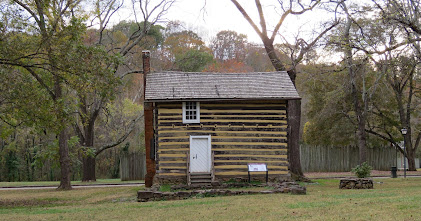
 Bethabara was a temporary location to be used while searching for suitable permanent town site so when Salem, North Carolina was founded in 1766, many of the buildings were dismantled and moved. On the site today are a church, potter's house, distiller's house, log house, and calf barn all which were built after the move. Bethabara was still an active town into the 20th century but not the industrial trade center that it had been. 


Bethabara Park has a visitor center with interesting exhibits and a short film. Members of the Moravian Church serve as docents. Guided tour of the church are given and the rest of the buildings have interpretive signs. Walking trails loop through the forest.
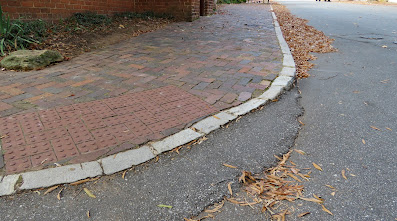
The visitor center is accessible but nothing else is. There isn't a sidewalk or trail to the buildings and the street is busy so it's not possible to roll down the street.
A large gravel lot is located to the adjacent to the visitor center. This lot is very rough so, if possible, park in the paved lot behind the visitor center. The paved lot has only one entrance/exit and there may not be room to turn around a large vehicle.  Park  36.15583, -80.29708


Thursday, November 21, 2024

Mount Airy Museum of Regional History

 Very nicely done exhibits cover the history of northwestern North Carolina - the Native Americans who were the first inhabitants and the immigrants who settled in Pennsylvania then followed the Great Wagon Road south. These same people built cities and established orchards and farms. Some preferred a most isolated home in the secluded hollows of the Appalachian foothills. 

There's also a train layout, tributes to some of the area celebrities, a kid's hands-on area, and several fire engines. Exhibits are still being added. During our visit one exhibit was under construction and third floor was mostly empty. 

One of the exhibits is about the famous conjoined twins Chang and Eng Bunker, born in Siam and brought to the US as eighteen year olds by Abel Coffin for a somewhat exploitative tour. They toured from 1829-1839 but managed the tour themselves from 1832 on. Their last stop was in South Carolina which they liked so much that they bought land and settled down to raise families, only leaving a few times when they needed to raise money. They died on the same day in 1874.  They have about 1,500 descendants; many still live in western North Carolina. Since only a small band of band of flesh and cartilage joined them, they could be separated today but probably would have died if it had been tried in their lifetime.

 
The museum is accessible. It's housed in the 1910 W.E. Merritt Hardware store which was very modern when it was built with electricity, water, sewage lines, and an elevator. I don't think the elevator is the original one but there is one so all the floors are accessible. 

Parking is on the street. Museum  36.50175, -80.6085


Monday, November 18, 2024

Andy Griffith Museum

The small town life of Mt Airy, North Carolina, where Andy Griffith grew up, was a big influence on the way he portrayed Sheriff Andy Taylor in the Andy Griffith Show which ran from from 1960–1968. The Snappy Lunch, Mount Airy Newspaper, local towns, and street names all were mentioned or made appearances on the show. Today Mt Airy plays up on the nostalgia and welcomes tourists to take a tour in an early 1960s Ford Galaxie squad car or buy souvenirs at Wally’s Gas Station. 

We know Griffith from his TV appearances as Sheriff Taylor and Matlock but we weren't aware that he was also an accomplished comedian, television producer, singer, and writer. Although the museum is small it features a large collection of artifacts and memorabilia and covers Griffith's childhood and 70 year career which included roles on Broadway and over a dozen feature films. 

The lower level of the museum has a mishmash of related items. The main exhibit is a collection of memorabilia from the career of Betty Lynn who played Barney Fife's girlfriend, Thelma Lou. There are also cutouts of some of the characters on the show. 

Both floors of the museum are accessible. Follow the sidewalk from the parking lot past the Andy Griffith Playhouse to the museum entrance. To see the lower level exit the museum and follow the sidewalk down. 

Parking is in the lot of the Andy Griffith Theater which is large enough for most RVs. Museum  36.49764, -80.60921


Saturday, November 16, 2024

Blue Ridge Parkway

 
 With still perfect weather and no strict schedule we decide to continue our ridge running south on the Blue Ridge Parkway. Although the Parkway and the Shenandoah N.P. both travel along the Appalachian Mountains ranges there are significant differences between the two parks. The Parkway is free and has many more access roads. Unlike the Shenandoah, which is surrounded by national park and wilderness land, the Parkway runs through national forest and private land. It's not unusual to see farms and houses next to the parkway. Shenandoah NP was mainly built by the young men of the Civilian Conservation Corp and while the Blue Ridge Parkway was also built through New Deal programs much of the work was done by private contractors. The Blue Ridge Parkway runs for 469 miles compared to only 105 miles for the Shenandoah. 

We've been careful to avoid areas that are still cleaning up from hurricane Helene's destructive rain and wind. The southern half of the parkway suffered washouts and landslides so our plan was to drive 200 miles on the parkway and exit at Fancy Gap. After driving about 100 miles we got off at Roanoke for the night because the campgrounds were already closed for the season. Our journey along the parkway ended there when our truck starter developed a weird problem. It wouldn't shut off after the engine caught. Before taking it to a shop, Tony tried an easy fix by disconnecting the battery and reconnecting it. Apparently there was a glitch in the programing and it needed to reset because it's been fine since. :) We were still uneasy about being far from service shops and continued our trip in the valley.

So the first 100 miles of the Blue Ridge Parkway:

 Some of the overlook parking lots on this section are very small with no turn around room and may have No Trailers signs.The elevation along the north end of the parkway is low so there's less haze than on Skyline Drive. At this time of year foliage ranges from nothing to classic fall colors depending on the elevation.

Humpback Rocks Visitor Center - this is a small visitor center with a few exhibits about life in the mountains. It is accessible. Historic buildings have been relocated to form a mountain farmstead. The first part of the trail to the farmstead is paved and accessible. The gravel section is accessible to the cabin after which it becomes steep and rocky. The buildings are not accessible. The parking lot is small and does not have any long spaces however it may be possible to park along the side of the loop road.

James River Visitor Center  - the visitor center was closed for the season but we tried walking/rolling along the short trail that leads to one of the few remaining locks from the Kanawha Canal. The trail is very steep with steps at the end of the pedestrian bridge so it's not accessible. The visitor center parking lot does not have long RV spaces. Shorter RVs may fit if backed up over the grass.

Peaks of the Otter Visitor Center - this visitor center was closed for the season too. The parking lot is small with no RV spaces but shorter RVs may fit if backed up over the grass. We backtracked 1/3 a mile to the Peaks of the Otter Lodge where there are RV/bus spaces and walked/rolled on the paved loop trail around the lake. The trail is in good condition and fairly level although the access trail from the parking lot is pretty steep. An accessible parking space is located near the entrance to the lot where the trail access is not as steep.

RVs can be driven on the parkway but be aware that parking is limited at the overlooks and visitor centers, at least in the northern section that we drove along plus there are twenty five tunnels, some less then twelve feet high at edge of the lanes. Sections of the Parkway are closed from late fall through early spring due to snowfall in the high elevations. Parkway     38.03072, -78.85773