Years ago when the level of Mono Lake was higher the tufa formations would have been underwater. They’re created when calcium-bearing freshwater springs react with the alkaline lake water to form limestone. Mono Lake has no outlet and historically the water level only dropped through evaporation or because of scanty rainfall however in 1941 the City of Los Angeles began diverting the streams that feed the lake. In 1994 measures to protect the lake were enacted and lake level is slowly rising.
Activities at Mono Lake include hiking trails, swimming, boating, dispersed camping, and visitor center programs.
The visitor center was closed during our visit and we only had time to go on the South Tufa Trail. The formations on this trail are said to be the best in the park. The trail goes from asphalt to boardwalk to hard-packed dirt. Wheelchair users may need assistance. About 2/3 of the way around the loop the trail becomes narrow and overgrown so backtracking is necessary. The visitor center and two more trails are accessible.
To access the Tufa Trail lot drive east about 4 1/2 miles on Mono Lake Basin Road then another mile on dirt road to the parking lot. This is navigable by any vehicle and the parking lot is large enough for RVs. The visitor center lot has long spaces and the other trails have lots that are large enough for RVs. The dispersed camping rules are a little vague so it may be best to check with a ranger. Mono Lake 37.93871, -119.02715
▼
Friday, November 29, 2019
Wednesday, November 27, 2019
Gorge Road Boondocking
A paved road off of US 395 leads to a power plant and popular rock climbing sites. It also branches off to head through BLM land and national forest land and eventually becomes a dirt road that joins back up with US 395. We wanted a spot for just one night so, after passing a couple of occupied sites, we found a small pull off with a wonderful view very close to the road. At this time of year, the road gets little traffic but at busy times I think better spots can be found by continuing down the road a way. Gorge 37.46784, -118.56592
Monday, November 25, 2019
Ruins of the Cerro Gordo Smelter
 In 1865 silver ore was discovered at Cerro Gordo by Pablo Flores. Over the years millions of dollars worth of minerals were carted down the mountain to the smelters on the shore of Lake Owens. The ingots produced by the smelters were then shipped to Los Angles which helped the young city’s growth. An eight miles drive on narrow, winding, steep dirt road leads to the small ghost town. Four wheel drive is recommended. The town is privately owned and tours can be arranged by calling ahead.
We did not attempt the drive to Cerro Gordo by we did try to get a closer look at the smelter ruins. The road we chose had a steep washout so we didn’t succeed but it may be possible to drive to ruins by using Cero Gordo Street.
The pull off, which has a sign about the history, is large enough for RVs. Cerro Gordo 36.4866, -117.8665
Sunday, November 24, 2019
US 95 Boondocking
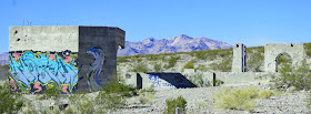
The desert is full of mysteries, both natural and man made. This one is man made. Someone started a large project with multiple building foundations and partially finished poured concrete walls topped with rebar. It’s surrounded by a flimsy wire fence which doesn't deter graffiti artists.
When I googled the coordinates to put them in this post I noticed a photograph titled Elizalde Cement Plant. More googling and the mystery is solved. This was going to be the site of a factory producing fancy cement made with crushed marble from a nearby quarry. A couple of events doomed the project. A fire in 1941 destroyed the just completed machine shop, storehouse, blacksmith shop and an office along with all the equipment. Rationing, after the US joined the fight against Germany and Japan in WWII, made it impossible to get the fuel need to run the factory.
This whole area is BLM land so we spent a quiet night in a large flat spot that was probably destined to be a parking lot. BLM 36.81919, -116.71708
Thursday, November 21, 2019
Neon Museum-The Bone Yard
The Neon Museum opened in late 2012 and we visited shortly after that in the spring of 2013. A lot has changed over the years. They are now part of the North American Reciprocal Museum Association (NARM) which means members get free admission. The tours are self guided so visitors can spend as much time as they like exploring the bone yard. We enjoyed the tidbits of information provided by the tour guide on our last visit however there is now a cell phone tour plus employees are stationed to answer questions and monitor the visitors. The signs are roped off which interferes with photographing them. The restored signs on Freemont Street have been removed for street construction. I don’t know if they’ll be replaced.


Security is very strict. Everyone must pass through a metal detector. Cameras and large bags must be checked in. Still photos using a phone are permitted. Check in at the booth at the entrance to the Cashman Center parking lot to pick up or buy tickets.
The museum is accessible. The paths are finely crushed stone and rolling is fairly easy.
The Cashman Center parking lot is large enough for RVs. Museum 36.17718, -115.1354
Wednesday, November 20, 2019
Hwy 62 Boondocking
Hwy 62 and US 95 travel through BLM land which extends to both side of the roads so boondocking opportunities are plentiful. This spot is particularly good because it has a large flat area, nice scenery and peaceful surroundings. I like the sign that spells out all of the rules for this area although we were surprised that a permit is need for campfires, barbecues, and gas stoves, and also that dumping gray water is allowed. Boondockng 34.20255, -114.41785


Tuesday, November 19, 2019
Shea Road Boondocking
This is a very popular boondocking area with a lot of room to spread out however washes limit the available space to a narrow strip along the road. The strip begins about 5 miles east of Hwy 95 and continues for about 5 miles. The road is in terrible shape for the first few miles but improves farther in. We found that as the road improves driving fairly fast evens out the bumps. Do not camp closer to Hwy 95 as this is Native American and Arizona state trust land.
The washes are used by OHV riders and are also the site of organized races during the winter months so the road may be closed at times.Boondocking 34.12392, -114.15331
The washes are used by OHV riders and are also the site of organized races during the winter months so the road may be closed at times.Boondocking 34.12392, -114.15331
Sunday, November 17, 2019
Homes on Wheels Solar Panel Awards

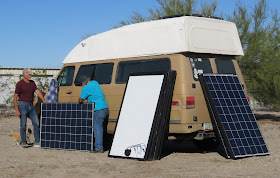
HOWA received a generous donation of 40 245 watt solar panels from SanTan Solar, a retail dealer of both new and used solar panels. Their prices are very good so if you’re looking for solar check them out! HOWA was also able to purchase 40 solar kits at a reduced price from Renogy – everything for a complete solar installation except for the battery which, unfortunately, was not in HOWA’s budget. Thank you San Tan and Renogy!
Testing the panels
Explaining all of the components in the kit
Solar kit recipients
Saturday, November 16, 2019
Railroad Pass Casino
Railroad Pass Casino marks the southern end of the Las Vegas and Henderson sprawl and the beginning of open road through unpopulated desert. It’s also a good place for truckers and RVers to stop for the night. Several large sections of the lot have been set aside for truck parking. RVers get a smaller section that has a slope. We parked in the most level space and still had to use our leveling blocks.
We did not visit the casino. Casino 35.97148, -114.9113
We did not visit the casino. Casino 35.97148, -114.9113
Friday, November 15, 2019
Crozier Ranch Boondocking
BLM land and private ranchland form a checkerboard pattern along historic 66 near Crozier, Arizona. At this location a dirt road accesses BLM land to both the north and south of Route 66. We camped on the south side. We didn’t go very far because we wanted to be sure that we stayed on BLM land.
Each access point has a gate which must be kept closed. Since some of the land is private there are special rules that must be followed. Stop and sign in and take a hang tag for your vehicle.

 This is a good, quiet spot to spend the night. The area is large enough for any RV but the soil is very dry and fine so avoid driving off road to minimize damage. BLM 35.45222, -113.62387
Each access point has a gate which must be kept closed. Since some of the land is private there are special rules that must be followed. Stop and sign in and take a hang tag for your vehicle.

 This is a good, quiet spot to spend the night. The area is large enough for any RV but the soil is very dry and fine so avoid driving off road to minimize damage. BLM 35.45222, -113.62387


